Not yet confirmedUnder investigation. Here is what is known and what still needs proof.
A Jordanian archaeologist says excavations carried out between 1996 and 2002 at Al-Maghtas, on the eastern bank of the Jordan River, show the “true place” of Christ’s baptism. Mohammad Waheeb of Hashemite University makes the case in a six-page, single-author paper in the Egyptian Journal of Archaeological and Restoration Studies, volume 16, issue 1. The claim circulated widely in the week of October 20, 2026, in the Daily Mail and other outlets. It is not a new dig. It is a fresh reading of finds that are at least 24 years old.
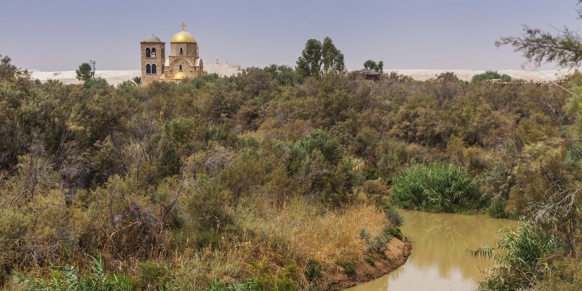
View of Al-Maghtas on the Jordanian bank of the Jordan River, taken from Qasr al-Yahud in the West Bank
The paper is titled “Neither Bethany nor Bethabara but Bethany beyond Jordan, site of Jesus baptism.” According to the journal’s PDF, it was received in January 2025 and accepted that December. The journal, tied to Sohag University in Egypt, describes itself as an international peer-reviewed publication.
Waheeb is not an outside observer. He built his case by matching ruins unearthed between 1996 and 2002 with descriptions left by ancient travelers and pilgrims. The paper itself says the discoveries were made by the author and his team. Nine of its 24 references are his own work. That is common for someone who directed an excavation, but it helps explain why the paper reads more like the excavator’s synthesis than an independent assessment.
The conclusion is strong. The paper says churches, baptismal pools, prayer halls, mosaics and water systems of the Roman-Byzantine era prove that this site, not the place called Bethabara, is the Bethany of John 1:28. The introduction mentions laboratory analyses, but the paper presents no dating data and does not say what material was tested.
The headline says “discovered,” but the ruins have been known since the 1990s
The exaggeration lies in the word discovery. Al-Maghtas has been excavated since the 1990s. The 1994 peace treaty between Jordan and Israel ended decades in which the area was a closed military zone, and digging began soon afterward, according to the report by UNESCO’s advisers. The site joined the World Heritage List in 2015. Six years of digging uncovered churches, baptismal pools, prayer halls and water systems, and that is the material the 2026 paper revisits.
The site has two main areas. One is Tell el-Kharrar, “Elijah’s Hill,” about two kilometers from the river, where a Byzantine monastery has three churches and three pools. The other lies near the water and holds the Churches of St. John the Baptist, roughly nine kilometers north of the Dead Sea. The report credits the first church there to Emperor Anastasius, between 491 and 518. It dates a stairway of 22 black marble steps, leading down to a pool, to about 570. The place was abandoned by the late 15th century.
There are older layers. The same report mentions a small farming community around 3500 B.C. and Hellenistic remains. But it places the site’s main development in the Roman and Byzantine eras, with the principal structures dating after the fourth century.
Waheeb himself has been more cautious in the past. In a 1999 piece for the American Schools of Oriental Research, quoted on Wikipedia, he saw a rectangular hall as a possible prayer space from the late Roman period, second or third century, though with a question mark. He placed the hill’s churches and pools in the fifth and sixth centuries. So the site is real, old and heavily used by Christians. What the paper adds is an interpretation, not a find.
John says Bethany, Origen preferred Bethabara
All four Gospels record Jesus’ baptism by John (Matthew 3:13-17; Mark 1:9-11; Luke 3:21-22; John 1:29-34). Only John names a place. John 1:28 says it happened in Bethany beyond the Jordan, where John was baptizing. In John 10:40, Jesus goes back across the Jordan to the place where John had first baptized.
There is another Bethany, home of Lazarus, Martha and Mary, near Jerusalem (John 11:1, 18). By adding “beyond the Jordan,” John appears to distinguish the baptism site from that other Bethany.
In the third century, Origen could not find any Bethany east of the river and proposed reading “Bethabara,” “house of the crossing,” the name of a place pointed out to him on the west bank. According to the Biblical Archaeology Society, Eusebius and Jerome followed him. The reading appears on the Madaba map and in the King James Bible. But the great fourth-century codices Vaticanus and Sinaiticus read Bethany, and most modern English translations follow them. Waheeb writes that Origen was mistaken to move the site west.
The landscape also echoes the Old Testament. Israel crossed the Jordan opposite Jericho (Joshua 3:14-17), and Elijah and Elisha crossed the river before Elijah was taken up into heaven (2 Kings 2:8-14). Ancient traditions link Al-Maghtas and Elijah’s Hill to those episodes.
Pilgrims and the Madaba map point to both banks of the river
The paper leans on travel accounts. The Pilgrim of Bordeaux, writing in A.D. 333, and Theodosius, around 530, both placed the baptism about five miles from where the Jordan flows into the Dead Sea. The Pilgrim of Piacenza, around 570, describes a very large monastery of St. John near the spot, with two hostels for pilgrims.
The five-mile figure has a limit the paper does not discuss. Qasr el-Yahud, on the west bank, sits directly opposite the Jordanian site, so the distance to the Dead Sea fits both sides. By itself, it does not pick a bank.
The Madaba map, a sixth-century mosaic in a church in Jordan, is more complicated. Journalist Rami Khouri, writing in Biblical Archaeology Review, notes that the map shows Beth Abara on the west bank, with a legend about the baptism of St. John. He suggests the mosaicist, who lived east of the river, may have understood “beyond the Jordan” to mean the western side. For the Gospel writer, he says, “beyond” plainly meant east.
Waheeb reads the map differently. He argues that its separate labels for locations on either side of the Jordan support the view that Bethany beyond the Jordan and Bethabara were distinct places. On the east bank, the map shows Aenon, “now Sapsaphas.”
Pilgrims never settled on one side only. Monasteries have stood on both banks since the Byzantine period, but the west bank was more accessible to pilgrims coming from Jerusalem and Jericho. Scholar Eugenio Alliata, cited on Wikipedia, wrote that by the sixth century the focus of veneration had shifted west.
The argument has a long timeline. In 1485, Brother Francesco Suriano recorded that the river had shifted its bed by about a mile. In 1899, Father Féderlin photographed the foundations of a chapel on arches at the mouth of Wadi Kharrar, and Father F.M. Abel still saw the arches in 1932. After 1967, both banks became a front line and were closed. Following the 1994 treaty, Jordan fully reopened Al-Maghtas in 2002, and Israel opened the Qasr el-Yahud site to the public in 2011 after mine clearance. The river’s shifting course also explains why the venerated spot today is now inland after the river changed course.
UNESCO’s own advisers urged caution in 2015
In 2015, ICOMOS, the body that advised UNESCO on the listing, reviewed Jordan’s dossier. It said the evidence does not prove beyond doubt that the structures at Jabal Mar Elias and the churches near the river are tied to Jesus’ baptism. It noted that several places along the Jordan have made similar claims. And it said it could not follow the archaeological arguments offered to prove the exact location.
ICOMOS did acknowledge that the vast majority of Christian denominations accept the east bank. It also observed that the wilderness setting described in the Gospels seems lacking on the opposite bank. The site was inscribed under criteria (iii) and (vi), which concern the tradition of baptism and pilgrimage, not as proof of the event.
Archaeologist Jodi Magness of the University of North Carolina at Chapel Hill told the Associated Press that identifying Bethany beyond the Jordan, on either bank, “has nothing to do with archaeological reality.” She said no site has remains that were continuously venerated from the first century on. The Biblical Archaeology Society adds that veneration on the east bank, shown by churches and a monastery, began no earlier than the Byzantine period.
Some scholars look somewhere else entirely. Not all scholars accept the identification, and some prefer a location north of the Sea of Galilee, by the Yarmouk River.
As for Waheeb’s central argument, the paper says the remains indicate the area was inhabited in the time of John and Jesus. That is a more modest claim than the conclusion that the baptism place has been found. People living near the river in the first century does not show that John baptized there.
For readers of John, the east bank is plausible, but the exact spot remains unproven
Waheeb, Khouri and ICOMOS agree on one point: for the author of the Fourth Gospel, “beyond the Jordan” means the east bank. Jesus came from Galilee (Matthew 3:13), and, according to Khouri, the usual route between Galilee and Judea bypassed Samaria by running south along the eastern side of the river. That makes the east a reasonable hypothesis.
What is missing is the link between the Byzantine ruins and the first century. With no inscription, find or contemporary text, the connection rests on tradition and on pilgrims writing centuries after the events, about 300 years in the case of the Pilgrim of Bordeaux and 500 for Theodosius. The 2026 paper does not close that gap. It reorganizes known data and reads them in favor of the east bank.
Jordan plans a Museum of Jesus’ Baptism at Al-Maghtas, expected to open in 2030, tied to the 2,000th anniversary of the baptism. Waheeb’s paper recommends preserving the monuments, continuing studies and creating conditions for tourism development at the site.